
Route
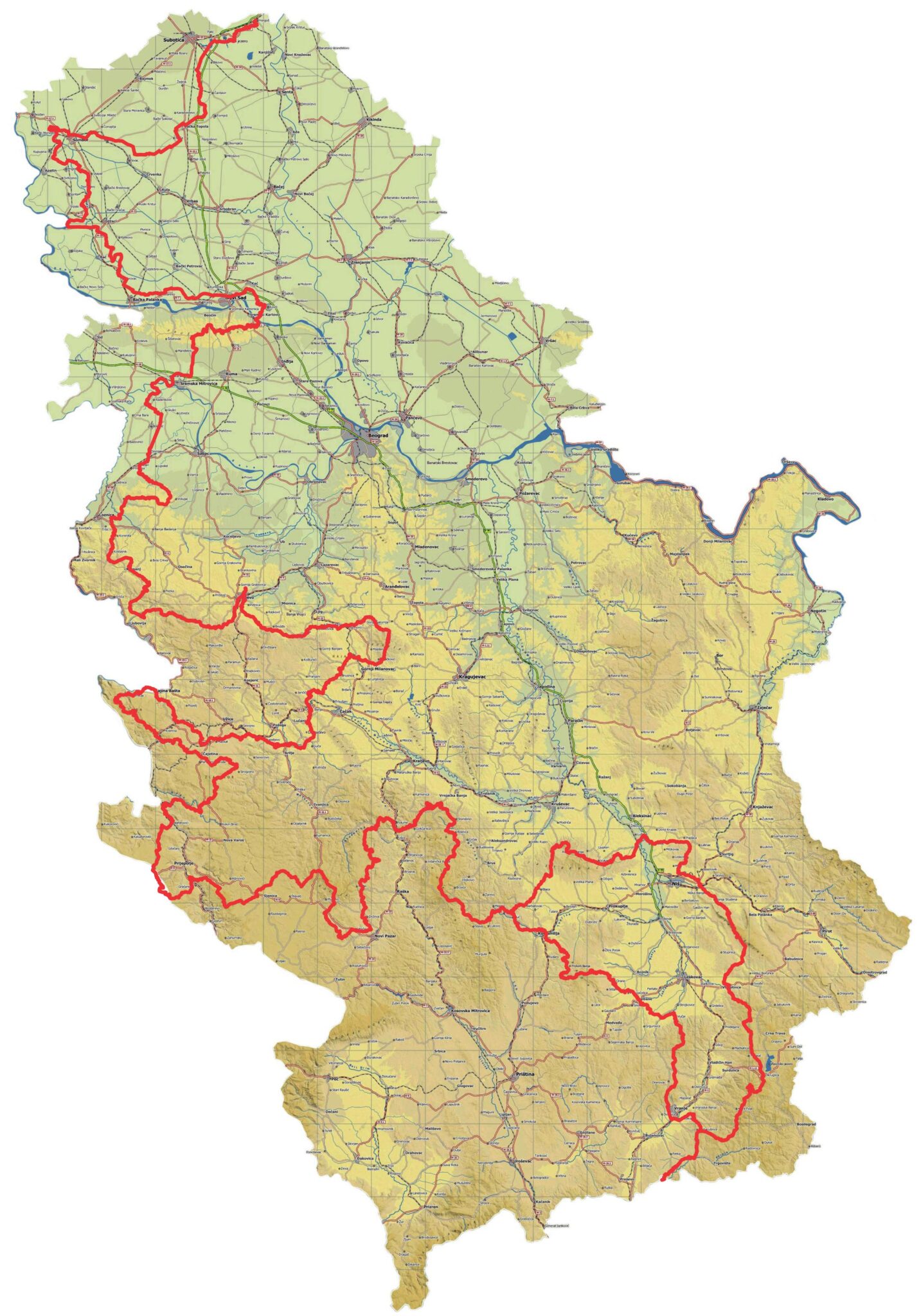
The Serbian part of E7 starts from the border crossing Bački Vinogradi. In a southwestern direction, after the two lakes of southern Pannonia, Palićko and Ludoško, through the outskirts of the historic town of Subotica E7 route continues south through the picturesque Zobnatica to Bačka Topola.
From the city of Sombor, the route approaches the left bank of the Danube and passes through protected nature reserves, and then down the Danube through old towns and ports, historic forts, by canals and embankments to Novi Sad capital of Vojvodina. Crossing the Danube, through Sremski Karlovci, over wooded Fruška Gora, past numerous monasteries, to the natural terraces of vineyards and orchards of Srem, the route crosses the Sava River near Sremska Mitrovica, formerly Sirmium, with a rich archaeological heritage. On the other side of the Sava River, the Mačva Plain begins, through which the old Zasavica watercourse meanders. It is a well-known ecological wetland habitat with diverse flora and fauna, a special nature reserve of high value.
The direction of the trail further leads through the plain of Mačva and climbs to the ridges of Mount Cer, famous for the defense battle of Serbia in World War I. From Cer, the road descends towards Tekeriš, then heading west over the Iverak mountain, descends southwest over Korenita towards Tršić. Further south, past the medieval Tronoša monastery, through Šarena Bukva on Boranja mountain, you reach a small town of Krupnj, and further, via Rožnj and Soko Grad, you descend to the Drina, a river of undeniable beauty and purity, to the town of Ljubovija. From there, take the eastern direction over the mountains of Tornička Bobija and Povlen, through the gorge of the river Gradac to reach the city of Valjevo.
From Valjevo, the E7 route rises again to the gentle mountain range of Divčibare, Suvobor and Rajac to the historical mountain Rudnik, whose name speaks of its origin and traces of mining from the early Middle Ages.
E-path E7 from here is already in Central Serbia towards the hills and monasteries of Ovčar and Kablar. From there, the trail descends into the tame valleys of Guča, where a thousand trumpets play at the famous festival and where fragrant and sweet raspberries grow around Arilje and the monastery of Saint Ahilija from the 13th century. From the town of Arilje, the trail takes us along the clean mountain river Veliki Rzav, through the villages of Roge, Drežnik, and Kriva Reka to Čajetina, on the Zlatibor plateau, and through the well-known village of Kremna towards the Tara mountain, a national park, with unforgettable viewpoints above Drina river canyon. These landscapes were originally preserved in pure nature. Through the pass of high Tara and next to Zaovine Lake, the E7 direction descends into the deep valleys of Mokra Gora and Rzav River, to the famous film center, the town of Mećavnik with wooden houses in the ethnic style of this region. Here is the extraordinary industrial heritage of the restored narrow-gauge railway, the famous “Šargan Eight”. Magnificent landscape beauty continues towards the high Zlatibor, the most visited tourist center of Serbia. The Continental Mediterranean climate has created extraordinary conditions for the health recovery of the visitor in his air spa.
Western Serbia with diverse natural and cultural values offers here the ethnic village of Sirogojno. Stopića cave, Gostilje waterfall, endless meadows with golden pines, and forests of Murtenica.
E7 from here heads west, past the Janja monastery, descends towards Pribojska Banja, and then across Lim, past the Mažići monastery, climbs to the peak of Borak on Pobijenik. From there, through the pass, past the village of Babine, it reaches Jabuka and the beautiful Kamena Gora, descending again into the Lim valley near Lučice.
The hospitality of the inhabitants of these regions will make your journey along this route more beautiful. Here you can see numerous examples of traditional buildings in rural households that are still well preserved.
From Lim, it climbs to beautiful waterfalls and old rolling mills and the source of the Sopotnica river, from where, via the wonderfully beautiful old village of Tičje polje with preserved old architecture, it crosses the high mountains of Jadovnik and Ozren. From here begins a gentle descent towards the Sjenica basin (part of the Pešter Plateau) and the town of Sjenica. The small village of Sjenica is known for its quality products, especially the famous Sjenica cheese. Very low winter temperatures are characteristic of this region. Nearby is Uvac Lake, with beautiful “pinched meanders”. Here, among other species, bald eagles (vultures) nest, in a strictly protected reserve, one of the largest in this part of Europe.
The city is beautified by the clear waters of the Grabovica and Vapa rivers, which flow into the Uvac.
From Sjenica, the E7 trail again approaches the upper part of the Uvac canyon, and then turns towards the ridges and peaks of high Golija, from where it continues towards the deep valley and the Sopoćani monastery at the source of Raška river, the old town of Ras and Novi Pazar.
Novi Pazar is an interesting city with a well-preserved Islamic heritage and lifestyle. It has valuable mosques and monuments from the period of the Turkish Empire. The heritage is preserved in the famous city museum. Here, the common life of the two great religions, Christianity and Islam, has survived for centuries.
From Novi Pazar, the E7 route passes by the Church of the Holy Apostles Peter and Paul (Peter’s Church), one of the oldest Christian sacred buildings, towards the Đurđevi Stupovi Monastery, which is being renovated, and then towards the Gradac Monastery, the endowment of Queen Jelena of Anjou, wife of King Uroš.
From here, the trail crosses the Radočelo mountain and descends to the Studenica monastery, one of the central monasteries of the Serbian Orthodox Church. The further direction of the route crosses the Ibar River and climbs to the ridges of the Željina and Kopaonik mountains, which is a large tourist center. Along the old mining and caravan roads, in addition to numerous traces of mining and sacred heritage, the E7 trail descends into the Toplica Valley and over the Jastrebac mountain further into the South Morava Valley. In this area, E7 encounters a zone of old Roman and early Byzantine settlements, Caričin Grad, the city of Naisus, today’s Niš, the center of southeastern Serbia. The Roman Emperor Constantine was born in Roman Naisus, the creator of the famous “Edict of Milan” on the freedom to profess Christianity. From Niš and Niška Banja across the Suva mountain and wide ridges of the Vlasina mountain, next to the tourist center on the Vlasina lake, the E7 route crosses to the vast, high mountain of Strešer, Besna Kobila and Dukat, with exceptionally well-preserved mountain nature. From these mountains, the trail descends into the valley of the Pčinja River and passes into North Macedonia close to the Prohor Pčinjski monastery. The deviation of E7 starts in the village of Žuč, near Selova. It passes through Kuršumlija, Prolom, a nearby natural attraction of Đavolja Varoš (Devil’s Town), and after Lebane and Vranje join back with the main E7 route near the monastery of Saint Ilija.
Starting Point
Bački Vinogradi (Border with Hungary)
End Point
Prohor Pčinjski (Border with North Macedonia)
Which cities and towns does the E-path pass-through
Bački Vinogradi, Palić, Subotica, Zobnatica, Bačka Topola, Sombor, Bački Monoštor, Apatin, Junaković Banja, Bač, Bačka Palanka, Čelarevo, Novi Sad, Sremski Karlovci, Vrdnik, Grgurevci, Sremska Mitrovica, Zasavica, Banovo Polje, Crna Bara, Bogatić, Ribari, Čokešina, Tekeriš, Bradić, Tršić, Krupanj, Ljubovija, Valjevo, Divčibare, Rajac, Boljkovci, Rudnik, Gornji Milanovac, Takovo, Ovčar Banja, Guča, Arilje, Roge, Čajetina, Kremna, Kaluđerske Bare, Mitrovac, Mokra Gora, Zlatibor, Sirogojno, Pribojska Banja, Priboj, Jabuka, Kamena Gora, Sjenica, Osaonica, Novi Pazar, Deževa, Rudno, Ušće, Goč, Kriva Reka, Kopaonik, Lukovska Banja, Selova, Blace, Jastrebac, Niš, Niška Banja, Veliki Krčimir, Vlasotince, Vlasina, Kriva Feja, Šajince, Prohor Pčinjski, Kuršumlija, Prolom, Lebane, Vranje
Length
2.113,3 km (Main route 1913,9 km and deviation 199,4 km)
Ground path of the E-path
E7 in Serbia connects multiple mountain path networks spread in the north, west, and south of the country.
Responsible organizations
Planinarski savez Srbije / Mountaineering Association of Serbia
Bulevar Vojvode Mišića 14, 11000 Belgrade
+381 11 33 43 137, +381 32 31 374
www.pss.rs, office@pss.rs
Mountain Terrain Commission – tereni@pss.rs
Publications
Kroz Srbiju peške lakim korakom, Planinarski savez Srbije, Belgrade 2011.
Srbijom – korak po korak, Planinarski savez Srbije, Belgrade 2024.
Maps
pkbalkan.org/korisno/evropski-pesacki-putevi-u-srbiji/
pss.rs/planinarski-objekti-i-tereni/tereni/?tip=evropski-pesacki-putevi-u-srbiji
Tara National Park; Mountaineering Tourist Map 2016-2024
Marking system
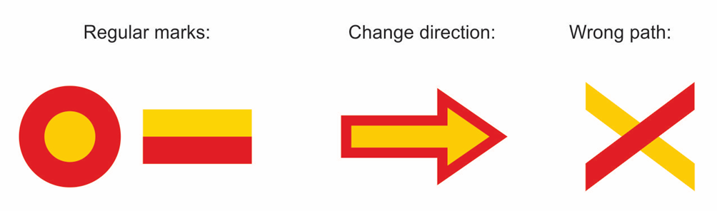
Crossing other E-paths
No crossings
Practical
Accommodation
There are different types of accommodation available along the path: mountain huts, private apartments and cabins, hostels, and hotels. In popular tourist sights, you can usually find nice camping areas if you would rather like to spend the night in a tent.
Food
Along the route, there are many places where you can be served with delicious traditional Serbian food. Ask for fish when you walk by the Danube or Sava river, for roasted pig meat when you are near Čačak, try „komplet lepinja“ on Tara and Zlatibor, taste fine cheese in Sjenica and of course „pljeskavica“ in the south of Serbia. As you are walking through hundreds of villages feel free to ask for domestic organic products that you can get directly from the farmers.
Travel
Although the train system is not in the best shape in Serbia it can be a good choice for some spots over the route (Subotica, Novi Sad, Valjevo, Zlatibor, Niš…) srbijavoz.rs/
The most reliable public transport method is the bus. There is no centralized bus service, so you will have to check the schedule by reaching local operators.
Shared car transport is becoming more and more popular. It is also an interesting way to meet the locals and to have a cozy and cheap transport. blablacar.rs/
Gear
No specific gear is needed, just a regular hiking one.
Links
Relevant links to e.g. tourist sites, weather sites.
pss.rs/planinarski-objekti-i-tereni/tereni/?tip=evropski-pesacki-putevi-u-srbiji
 Eurorando 2026 – Europe’s biggest hiking event!
 20–27 September 2026
 Ore Mountains (Erzgebirge), Germany–Czechia
 50+ guided hikes


